
Being a fellow “from off”, please allow me latitude as I relate the story the Banks and the C’ae bankers have been telling me. This is just a taste of the story I have accumulated but my hope is that it will be a fair partial representation of the Banks story.
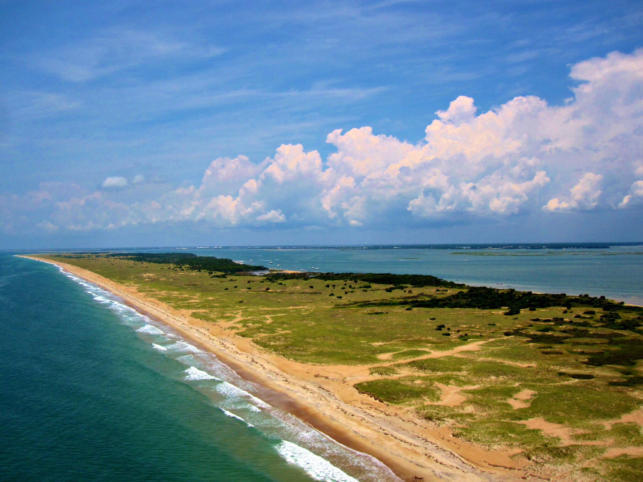
Where are the Core Banks….”ribbons of sand” separating the Atlantic Ocean from Core and Back Sounds–banks that shift, migrate and re-shape due to ocean currents and forceful storms.

Core Banks and Shackleford Banks –56 miles–now are part of the Cape Lookout National Seashore.

Moving here in 1983, and like so many others from “off”, my knowledge of the Banks was initially limited to how I saw and used them–boating, seashore gatherings, visits to see a new foal on Shackleford Banks. Only, after many years, when Charles Perry Styron shared the story of his family’s beloved camp, did I begin to learn of and understand that the story of Core Banks and the culture of deep personal connections held by Bankers were important and at risk of being lost.
Historical Importance—Personal Importance

First……a look at history……(acknowledging that history is interwoven with personal history, stories, and emotion)

Although I believe Core and Shackleford Banks have significant local, regional, state and national historical impacts, I would further contend that the personal and family stories of the C’ae Bankers—their connection to and love for the Banks created a special culture worth documenting.
Let’s explore North to South , and also over time, as a framework……..

Portsmouth Island and Ocracoke Inlet….
Beacon Island and Shell Castle (seen here only as small islands deep within the inlet on this view) are of early importance…. but one part of the story long precedes them.
Early Indigenous People…
We weren’t the first here.

The Coree, of the Algonquians, were known for their proficient harvest of fish. A projectile point dated to 5,000 years ago has been found in the seashore recently.
Smithsonian documents show accounts of a Native American tribe of 85 individuals found living on what we now call Cape Lookout . They called the site and themselves-“Croatan”.
Coastal settlers abused the Native Americans–cheating them, taking their land, harming their women and capturing and selling large numbers into slavery. In the 1711-1712 Tuscarora War, multiple tribes attacking together to massacre 130 settlers, resulted as the Indian retaliation to the abuse. After defeat in this war, they were moved to Mattamuskeet and later went to join their tribes in New York. The Native American presence then faded from coastal N.C. from that point.
Communities on the Banks………..
Portsmouth Village….was just one of several Banks communities…

Portsmouth was a major port in pre-Revolutionary times and had Revolutionary and Civil War Forts. During the Revolution, as northern ports were blockaded by the English, supplies reached George Washington’s troops through Ocracoke and Topsail (now Beaufort) Inlets. Portsmouth played a role in the War of 1812, WWI and WWII as well. The U.S. Life-Saving Service, market hunting, and later, Northern sportsmen visiting to hunt are part of the story here.
https://www.nps.gov/calo/planyourvisit/visit-portsmouth.htm click for great content on Portsmouth Village History
Other Communities…
Near Portsmouth…. were the Middle Community, Sheep Island, and also scattered family compounds alongside the sound-side shore going South.
Much further south………..at Cape Lookout– was “Rose Town (later becoming Cape Village)….and eastward about 2 miles was Lookout Woods (later called Diamond City), further west… the Bell’s Island and Wade Shore communities also existed as established social settings on Shackleford Banks–some with churches and/or schools..along with some shared local industry. (boatbuilding, whaling, fishing, porpoising)–the map below shows their locations.

Several of North Carolina’s and our nation’s earliest settlements and communities were on Core Banks.
Settlers….
Settlers migrated south from Virginia and theChowan River area in the 1600’s and likely scattered into the Banks early on (mid 1600s)…von Graffenried in 1713 described the Bankers on Shackleford Banks as providers of “seafood of all kinds” for the mainland settlers.
…once asked how long their families had been on the Banks, the Banker response was: “we’ve always been here”.
{John Porter obtained a grant for 7,000 acres of Core Banks in 1713 and sold his holdings to John Shackleford and Enoch Ward in 1723. They split the holdings, giving Shackleford Banks its name. It appears that they used the Banks as convenient, fence-free grazing land initially.}….
.back to Portsmouth
Portsmouth and the Maritime Trades….


Portsmouth was a busy place, especially for that day….. a key port for entry of maritime trade to this mid-Atlantic colony.
It was “lightering port”…..deep drafted vessel transferred cargo to more shallow drafted vessels that could navigate the shallow sounds to reach coastal communities.

Beacon Island…the first site for maritime trade in Ocracoke inlet…

Although Beacon Island is now only a large sand bar preserved as a bird sanctuary by Audubon–it previously held both a Revolutionary and Civil War Fort after serving as the original entry point for Ocracoke Inlet …prior to the establishment of Portsmouth as the official port. Beacon Island Lodge was active as a hunting camp in the early 1900s. Floyd Simmons hunted there.
Shell Castle...
Only 60feet wide and a half mile long, Wallace and Blount developed Shell Castle into the prominent site for maritime trade—–with wind mill, light house, wharves, warehouses and lodging for a large staff. 1,400 vessels a year were served at the Inlet’s peak of activity.

Slavery.…Portsmouth was part of “the Middle Passage”….

The Snow Hannah, of Liverpool,(as one example) is documented to have disembarked 258 slaves in Ocracoke Inlet in 1759. Besides transit through the port, enslaved persons were also sold at “Shell Castle”.
In the community, slaves were engaged in the lightering process and maritime trades–enslaved people constituted 36% of Portsmouth’s population in the 1850s. As Union forces threatened the area, many families fled Portsmouth, taking their slaves with them. (more on the NPS site above)
Only a few prior enslaved persons returned to live in the village after the Civil War.
First Hospital…

Sick or injured crew members were often left behind on Portsmouth to avoid the burden of care and prevent potential quarantine at the next port. With 1,400 vessels per year visiting, the local and make-do resources were stretched thin and found insufficient. The Federal Government established several hospitals in key ports to serve this need. The U.S. Marine Hospital in Portsmouth Village was North Carolina’s first structure built for the purpose of serving as a hospital in this state. (click link for more)
Life-Saving Service and Coast Guard….

Much of the crew of the 1894 Life-Saving Service at Portsmouth came from the local population and isome ncoming surfmen also chose to stay and live there after their stint in service.


Great content about this station can be found on the Park Service site–
https://www.nps.gov/calo/planyourvisit/visit-portsmouth.htm
Coast Guard Beach Patrol…WWII…

World War II saw the establishment of horseback beach patrols on North Core Banks and other barrier islands northward to the Norfolk area. Cape Lookout and the geographically connected South Core Banks had a large conventional and motorized military presence. Shackleford Banks had Coast Guard foot patrols based mid-island in a structure that would become Dr. Moore’s camp in later years.
Village Life…

Portsmouth had a peak population of 700 inhabitants prior to the Civil War. After the war, only a few previously enslaved persons returned to live as free men and women. Decline in maritime trades occurred due to a shift in the channel of the inlet…favoring Ocracoke for commerce…..along with the natural opening of other inlets and new harbors along the coast.
Fishing and harvesting from the marshes, market hunting, and the Life-Saving Service were among approaches to sustain the smaller population. The church was a center of life there and this well-maintained structure remains the most precious of those remaining on the island. The school and Post Office served as hubs of the community as well (mail came on the twice daily mailboat).


Mary Dixon came as teacher in 1916–the students were given a stuffed Albatross by a Coast Guardsman to serve as their “mascot”.

Locals gathered to share music, sometimes challenged the surfmen to croquet, the young people gathered together regularly in the afternoon, and the beach brought some adventure.

Round-ups…….

“They dined on waterfowl all winter, and nearly every islander made an important, extra bit of money by raising “live decoys,” which were Canada Geese with clipped wings that hunters used to entice wild geese into shot-gun range.
In autumn, they held a “goose round-up” and drove several hundred geese, already marked as to ownership, out of the salt marshes and into a pen on the property of George Gilgo. A local waterman, Gilgo was renowned for his way with birds. There, they divided up the geese and sold them to hunters.”
Hunting….Guiding…

Fishing…

Ted Williams came to North Core and Portsmouth to fish for Drum with Grady Sheets. Fishing on North Core Banks grew in popularity from the 1930s onward.
One individual story…..
Henry Pigott was the last man to live on Portsmouth, living in the village near Marion Babb and Elma Dixon. Beloved to everyone that met him, his home site is restored and maintained at Portsmouth Village. He died in 1971.


Cooling Houses had a screened bottom and 4-sides and was placed to capture any breeze. Milk, eggs, perishables and left-overs were kept there to prolong their availability–found better than any site inside where no refrigeration was available.


Lionel Gilgo, living as a youth at Portsmouth, remembers visiting numerous family compounds on the sound-side shores to the south of the village as he traveled with his father.
South of the family compounds was the home of James Mason….

James Mason purchased multiple tracts of land (“grants” from the state of N.C.) for 25 cents an acre. He lived along the shore (about mid-island), with his schooner anchored off the shore, till his home burned The Masons moved to Beaufort to live in the Hammock House. In the late 1800s, Mason sold land to and built a lodge for Theodore Rogers. Mason’s children and descendants were caretakers for what Rogers named “The Pilentary”.
A visit to the Mason home on North Core Banks was documented by Nathaniel Bishop……as part of his 2,500 mile canoe journey…

https://www.ibiblio.org/eldritch/nhb/paperc/c10.html
Northern Sportsmen in the early 20th Century….(Theodore Rogers, President of the bank of the Metropolis in Manhattan was one)……..

The Pilentary was the most grand of any of the structures ever on Core Banks. Though only spanning a few decades, the story of the Pilentary is rich and deep–connecting now-living locals and the memories of the Northern sportsmen.
Origin of the lodge’s name…….


Jordan Mott was a friend of the Czar of Russia and the German Kaiser, and the Armour’s , as well as Roosevelt…he was a titan of industry. His internationally known foundry was the source of his income and connections.

The un-named 1933 storm brought the Pilentary’s end…caretakers survived by sheltering on the highest dune nearby.

North Core Banks, in the 1900s, especially after WWII, provided sites for the numerous hunting clubs, the Charlotte Outing Club, many fishing camps and small seasonal communities. Thousands of individuals made generational memories there.
The Charlotte Outing Club established a camp north of Drum Inlet in the early 20th century….outing clubs nationally were eventually incorporated into the Sierra Club.CHARLOTTE OUTING CLUB
There were very many smaller hunting and family camps on North Core Banks.

We will look at South Core Banks, Cape Lookout and Shackleford Banks separately …while acknowledging their history and geography are interconnected.
Station “Atlantic”—

Station “Atlantic“…site of the vessel “Melrose” rescue, among others.

Clay Fulcher and others have shared the history of the decommissioned station as a favorite spot for locals to have community shrimp boils, cookouts and gatherings with friends. When “private property-no trespassing” signs went up from owners, there soon followed a fire that destroyed the structure. Burnings were a not-infrequent regional vengeful act against others.
Core Banks Club….the club/camp with the longest documented story of use–1901 till 1999.

The Core Banks Club was along the sound near mid-island. The “Clubhouse” had a century-long presence–rebuilt after a 1971 fire, but persisting in use till 1999. Initially owned by wealthy Northern Sportsmen, WWI and the Depression were followed by its desertion and change into the hands of regional owners. Babe Ruth, Sam Snead, Bob Timberlake and many politicians were guests.
Fishing Camps….

Sterling Dixon established the first ferry service to and fishing camps on South Core Banks. Ira Morris duplicated such a venture on North Core near where Avon Mason and Wilbur Nelson also had such camps. Winston-Salem and Forsyth County citizens seemed to make up the base of growing activity from the 1930s on. The Davis Island Fishing Foundation (D.I.F.F.) is still active.
Nine Islands Club….

Edwin Binney was the inventor of crayons, developer of effective black-wall tires, won medals at the World’s Fair and was an avid sportsman. His daughter, Dorothy, flew with Amelia Earhart on several record-making flights. Their friendship severed as Earhart came to later marry Dorothy’s spouse.
There were scores of camps and cottages along the shores of South Core Banks at the time of the transition into a national park.

Again, we were not here first…..
Indigenous Native Americans

Smithsonian documents show evidence of the 1585 group of Native Americans at what we call Cape Lookout…they calling the area and themselves “Croatan”.
Settlement…”we’ve always been here”….(the response to query of how long their families had lived on the Banks)
In the mid-1600s, scattered settlers established on North Carolina’s outer banks, but certainly they were there in 1713 when von Graffenried mentioned them as providers of all sorts of seafood for the settlers (those on the mainland).
Caleb Davis had an “ordinary” in Cape Lookout Bay in 1765. The two-story structure served both as a tavern and provided housing and board at the time. A tall flagstaff nearby may have served for navigation into the bay.
The 1764 map made by the H.M.S. Viper shows “whaler huts” west of the Bight. This Banks area was the most active area for whaling along the East coast south of New England
Anson Lewis (b. 1740) was one of, if not first, of the Whalers.

Spanish Privateers had used the Bight for refuge and a “hiding place” in the 1740s. Raids to shipping and harbor towns brought about the plan for a fort to defend the Cape Lookout Bight. The Revolution started without it being built.
Revolutionary Fort….
French Captains de Cottineau and de Cambray arrived at the Cape, en route to join the colony’s efforts for independence and seeking commissions from George Washington and Congress. Captain de Cottineau and his ship went on to fight alongside John Paul Jones. Seeing the need for local defense of a key anchorage, they led the construction of Fort Hancock at the Bight near the site of the current lighthouse.

Being an effective deterrent, the Fort did not see battle and was decommissioned after Independence.
Entry into the 20th Century….

Documented accounts describe the lifestyle and the setting in the Cape Lookout Bight area from 1870 onward from the viewpoint of the fishermen who lived there seasonally or full time. The “old fort” and the site of the porpoising activity were mentioned in records, as well…both near the “haulover” site and lighthouse.
Jack Dudley presents a photo of “Rose Town” in his book..”Southern Outer Banks”. “Rose Town” evolved into the Cape Lookout Village entity that shared a timeline with Diamond City…within sight and to the west. Cape Village had a school and post office for a brief period (closed in 1916). One account mentioned a population of 85 individuals.

The building of the jetty under supervision of Carl Josenhans is also an interesting story of that period (1915).
Cape Lookout Lighthouse

Congress directed the construction of the initial lighthouse. The structure consisted of interior stone with an exterior of wood–painted with horizontal stripes. The shoals of the Cape extend 20 miles out to sea and the height and location of this light proved ineffective. It was replaced in 1859 by a taller tower of red brick, positioned on higher ground 300 yards to the west of the 1812 lighthouse and it was also equipped with a Fresnell Lens that was a large technological improvement as well


The 1812 lighthouse served as quarters for the assistant keeper after the 1859 light was functional. The lens was removed by Confederate troops before they retreated from Union movement to the area. Later, Confederate forces attempted to destroy the reactivated light with gunpowder charges but succeeded only in destroying the lower wooden stairwell by the fire.

The new paint job in 1873 faced diamonds north-south and east-west to aid navigation. The new look gave rise to the change in name from Lookout Woods to Diamond City for the community to the west.

U. S. Life-Saving Service and Coast Guard—

The 1887 station crew saved the vessel Sara A. Rawson, going out with every surfman suffering from Influenza and braving severe adversity. They received the Life-Saving Medal for their heroism. Tyre Moore was one of this crew and was also on the crew to save the vessel Sylvia Hall–a rescue that put the station in the history books.
A new station was built in 1917 alongside the 1887 structure which was later sold and was then moved to Cape Village where it still stands.

The 1917 Coast Guard Station is part of existing historic sites in Cape Village currently.
Coast Guard’s First Rescue of a vessel……

The Life-Saving Service became part of the newly formed U.S. Coast Guard in 1915. Fred Gillikin, Tyre Moore, surfman Yeomans and the crew made history when they rescued the vessel Sylvia Hall–the new Coast Guard’s First Rescue. (click links to read more)

German Submarines sank numerous vessels off the Banks and there was fear of landings on our coast. Cape Lookout was converted into a safe harbor with submarine net barriers and naval guns and substantial military presence at the Cape. Local fisherman also formed a volunteer fleet to spot for submarines. Owners at the Cape were given nominal reimbursement for the use of their structures which were later returned to them.
Some families of the servicemen lived with them in structures of Cape Village and nearby. The Royer baby was the last baby born to and active Cape resident.
One of the favorite local stories involves local Denard Davis, who moved military equipment into place with one mule and a set of pulleys and capstan… when all the motorized equipment failed in the sand. “Denard and the Sand Stuck Guns” brings a grin to locals because the military initially scorned the idea of his success.

Harbor of Refuge….


Development???….attempted through the years….
Repeated efforts to develop Cape Lookout happily did not succeed.
The Cape Lookout Development Company planned to run a railroad to Shackleford Banks and over to the Cape around 1922. The 1933 storm would have made a mess of their plans.
A few of the proposals included …a highway from Harkers island to the Cape, plans for piers, and Charles Reeves’ presentation of his marina, hotels and airfield… on the right, below.

Historic Cape Village–on the National Registry of Historic Places..designation occurred after a concerted efforts by the previous owners of the Cape Village structures …a successful effort to prevent their demolition.


Communities
von Graffenried, in 1713, described Shackleford Banks as “populated almost entirely by Englishmen who furnish seafood of all kinds to the settlers”.
John Porter obtained the initial grant of ownership in 1703 and sold his holdings to Enoch Ward and John Shacklford in 1723. Shackleford Banks was used initially (and later) as grazing lands for livestock…the shore provided natural “fencing”.
“Progger” is a term for self-sufficient individuals that constantly adapt to harvest what is available at the time…fish, oyster, scallop, clams, turtle, ducks and geese, loon, gardens, or whales for their sustenance and/or for sale and barter. Such individuals populated the Banks.
Communities emerged at Lookout Woods ( 500 individuals..church, school, 400 site graveyard…..renamed Diamond City in 1873), Bell’s Island and Wades Shore. (see map further below)
Lookout Woods…Diamond City….

David Lawrence created a rendition of a typical Diamond City structure from written accounts.

Sparsely populated in the mid-1600s, Diamond City (previously known as Lookout Woods) would grow to a village of about 500 people . Communities also were established at Bells Island and Wade Shore, along with other scattered family compounds.
see” Diamond City-A Homecoming” for additional info Diamond City–A Homecoming (click the link)
The severe hurricanes of the mid-1890s were followed by two devastating storms in 1899. The entire island was under water.
Not only losing their livestock, boats and equipment, gardens, loss or damage to homes..and the salty soil and fouled water supplies..all left them little option to carry on.


The Exodus from the Banks saw disassembled and entire houses floated to new homesites in Morehead City (Promise Land), Harkers Island, Salter Path (on Bogue Banks) and Beaufort. In each setting, they often clustered their homes to retain community connections and contributed strongly to the culture of those new areas.

“Mullet Camps”….
Fishing Camps were seasonally constructed on the Shore of Shacklford Banks. Crews gathered and constructed their camps out of marsh reeds (some lasting more than a decade) as base for their mullet fishing. Farmers, yearly, came in their off-season to join fishermen and be part of the crew… providing the farmers an extra income from the share they received at season end. (featured in National Geographic at the time)
Shackleford Banks and Beaufort were the site of the last revolutionary battle …
British ships arrived from Charleston, S.C. to attack and plunder the city warehouses. Just as Portsmouth had done, this inlet and storehouses were a source of supplies for forces under George Washington…since northern ports were blockaded. Local militia under Enoch Ward repelled the invaders from Shackleford Banks where the ships were attempting to take on water. (Unfortunately, they had been more successful in Beaufort, but did not get to warehouses on Harkers Island.)


Having explored selected “snapshots” of the historical contributions of the Banks, I hope to show glimpses of the special emotional connections to the Banks held by locals..

Many did continue to embrace the Banks. In 1976, there were 400 structures on the Banks..hunting camps, get-away cottages, fishing camps—many with multigenerational stories and long presence on the Banks. Young descendants of these owners have recently said that, even they, feel, as their feet touch the sand on the Banks, that “they are home”.
Hunting Camps were a part of the story….

Jule Hamilton’s well-known“Evergreens” camp generated great memories and entertaining stories. Evergreens was one of many multi-generational camps.

Judge Lambert Morris‘ “High Hills” camp was rebuilt after it was vengefully burned. A decoy and shorebird carver for his own use, his birds are prized.
Gathering in the courtroom, occasionally, the announcement came that court was cancelled because the hunting was good on the Banks.

Morton Davis‘ “Seagirt” welcomed many friends and fellow hunters. Grandson Jim still hunts (now from a houseboat base” on the same creek to stay near his memories.
Family Experiences……another important part of the story...

“Wib’s”, named after Wilbur Nelson, was a community of 14 or so structures where winter hunting, summer fishing and summer-long retreats for families happened. George Hill had had a home here till the 1933 storm destroyed it. Julian Hamilton, Sr. had owned some of the area in the early 1900s.
Freddie Hooper‘s son told Clay Fulcher (recalling his youthful days at the Hooper camp there)…...”Clay….these days, if I dream, I dream of the banks”
At the Cape——


Charles Reeves and Sam Bass built the “A-Frame House” near the lighthouse. Flying in to land on the sand flats or arriving by sailboat, good youthful times there have led Sam Bass, Jr. to write a memoir, “Boys on the Edge”.
A youthful viewpoint—

1966 Chevrolet Commercial —filmed at the Cape–

Inspirational Impacts.……….

Harry Davis, descendant, who later owned the Cape Coca Cola House became the Curator of the N.C. Museum of Natural History and carried out research on the Banks.

The Josenhan’s Cottage (mis-named the Jetty Worker’s Cottage…it was used only by the Josenhans family) passed down through family to the Longs and Bournes. Joel Bourne, who spent much time there, was the Chief Environmental Editor for National Geographic and continues to write environmentally focused books and articles. Life on the Banks is inspirational. His Cape memoir will be published soon.

“Casablanca” is a house with many wonderful stories. Emma Rose Guthrie played alongside its artesian well with friends as Ms. Baker watched and smiled, WWII saw it used by the military, hundreds of friends and families gathered there. through the decades.
Melissa Moye points to her time there, watching for the migratory birds returning or otherwise immersed within nature, as a starting point in her career. She has served as Chief Financial Officer for The World Wildlife Fund.
Charles and Cindy Styron…


Charles and Cindy Styron shared a camp with his parents at Wib’s or Webb’s Creek. My interest in the Banks story resulted from them sharing their family’s love for their camp… creating shorebird art for kitchen cabinets….keeping a depiction of the camp on their wall,…rich stories of time there…..and Charles and Cindy spent their honeymoon there. This camp was multigenerational with deeds back into the early or mid 1800s.

I was surprised to learn that there were more than 400 more personal camp stories…not to mention the other pre-1976 Banks history and regional stories.
Sharing info on a few more of these family camps(following below) will give a feel of the special nature of these connections with the Banks. (click on the red link to learn more about each)
Turner family…

Charles Lewis and Ghermann Holland

Charlie Lewis built this camp in 1934 after their home at the Mullet Pond was destroyed. His friend, Ghermann Holland bought it and it was active till the Park takeover. It was destroyed by arson–having legal deeds and obtaining a 25 year lease (as did Dr. Moore and Edna Heslep), “the boys” said, if we can’t keep our camp, they can’t have theirs and burned all three camps.
Edna Heslep

Edna Heslep was Dr. Moore’s beloved nurse. Many people have told the author of their time there. Family time walking the shore or fishing, getting away and living simply and peacefully.


Bell’s Island got the nickname “Little Miami” because of the many camps clustered together in community. This was the site of the community of the same name at the century’s turn.
Emma Rose and Garland Guthrie had a camp here. Similar clusters at Wib’s, Bald Hill Bay, and Wade Shore also created get-away communities that were precious to them.
Painful Loss
Emma Rose Guthrie was returning to her Harkers Island home from shopping in Beaufort and as she crossed the North River bridge she saw, to the south, three white plumes of smoke rising from Shackleford Banks. She knew in her heart that one of the plumes was her and Garland’s beloved camp on Shackleford Banks. She was correct.
Emma Rose had been born in the year of the 1933 un-named storm and her grandparents had lived in Rose Town and Cape Village till after 1916. She had spent un-countable days in the Coca Cola House at the Cape, and she and Garland shared a friend’s cottage at the Cape after WWII—till a storm washed it out to sea.
Their later camp at Bell’s Island was her joy and precious connection to her family’s way of life. Emma Rose convincingly states that she wished she had been given the choice—burn her camp or her mainland home—she would have had the Harkers Island house burned instead.
There is a deep sense of loss conveyed.

A New National Park………………….

Congress mandated that the new park would be returned to a state of “wilderness”.
This encompassed an eventual loss to 400, or more, families of their beloved camps, cottages and Banks lands. Fishermen, however, successfully banded together to advocate for continued beach access by vehicles for use in fishing and camping.

Some locals are reported to have said..”if anybody’s going to burn my camp, it will be me”.
Removal of livestock….


Local advocacy led to a plan to keep a herd of about 120 horses as a continuing free ranging herd on Shackleford Banks. All the other creatures were rounded up and removed as much as possible.
Other chores..to reclaim the Banks…

A big challenge was the removal of 3,500 vehicles in various stages of deterioration and widely scattered trash heaps. The debate still continues–that cars build better sand dunes than Christmas trees.. Many remains of vehicles still continue to emerge after each storm.


Burning the Camps….

Burning of the structures was an unfortunate choice for their removal. Already feeling mistreated by the loss of their structures and the fact that some (with lawyers and connections) got leases or better reimbursement, and then having their camp burned was hurtful. Burning was often seen regionally as a vengeful act …it was like throwing gas on a …..
Also, being prevented from harvesting from the same creeks and marshes used for generations seemed unfair. Access and use of the Banks now came with difficult restrictions. Locals had and have hard feelings.
View from the another side...
The early and un-suspecting Park Rangers coming to this brand new Park— anticipating a wonderful experience in the Parks creation — found animosity and exclusion. Being shunned and threatened, gunshots into their houses, the Ranger station burned, their children not accepted by others–they endured a great deal as well. They were uneasy wearing their uniforms in public places. (These memories were shared by them with me at a “reunion”). Their visibility made them the targets available to locals, though they had not set the policies used. Animosity slowly melts away and many locals now admit that they are glad the Banks they love are protected from development.
Clay Fulcher once took me to the site of his camp on North Core Banks and while he did some chores, I walked to the beach. I stood looking north and south to see only dunes, surf, sea oats, and shorebirds. I felt blessed to see the Banks like the Native Americans might have seen them. Walking back, I looked down to see a perfect Scotch Bonnet on the sand. It sits with me at my desk every day as my remembrance of that day and of the story there Banks has told me.

Thanks for taking a look. Stan
More Information…on camps, cottages and the Banks can be found by searching the Camp Guide on the Home Page of this blog or inserting a name in the Search box………..currently, there are 264 individual camp “pages” with their info and over 360 camps on record.
…….including Club Rouse, Cigar Ranch, Earl Noe, Earl Davis, Dr. Luther Fulcher, Dump Island camp, Armtex, Avon Mason, Battle Boys Camp, Billy and Janice Smith, Walker George, Wayne and Lana Davis, 58 Shackleford Banks Camps..1977, Staton Moore, Sea haven, Terry Dedmon, the Barden Cottage, Timon taylor, Rams Club, Robert Lee Humber, Ross Salter, Roy Eubanks, Sam Windsor’s Lump, Scotch Bonnet Camp, Monroe Nelson, John L. Smith fishing camp, Houston Salter, James Ray Willis, Frank Nelson, Gordon Willis, and the Hansen Cottage……and more
Additional content is constantly being added–and if you have something to add or to correct, please let me know………Thanks again
Leave a Reply