Contents
Story
Decoys
Credits

🟡 STRONG RESEARCH VOLUME
OWNERS
Original LifeSaving Station
Main Coast Guard Station
1888
1916–current day
OTHER ASSOCIATIONS
Cape Lookout National Seashore
LOCATION
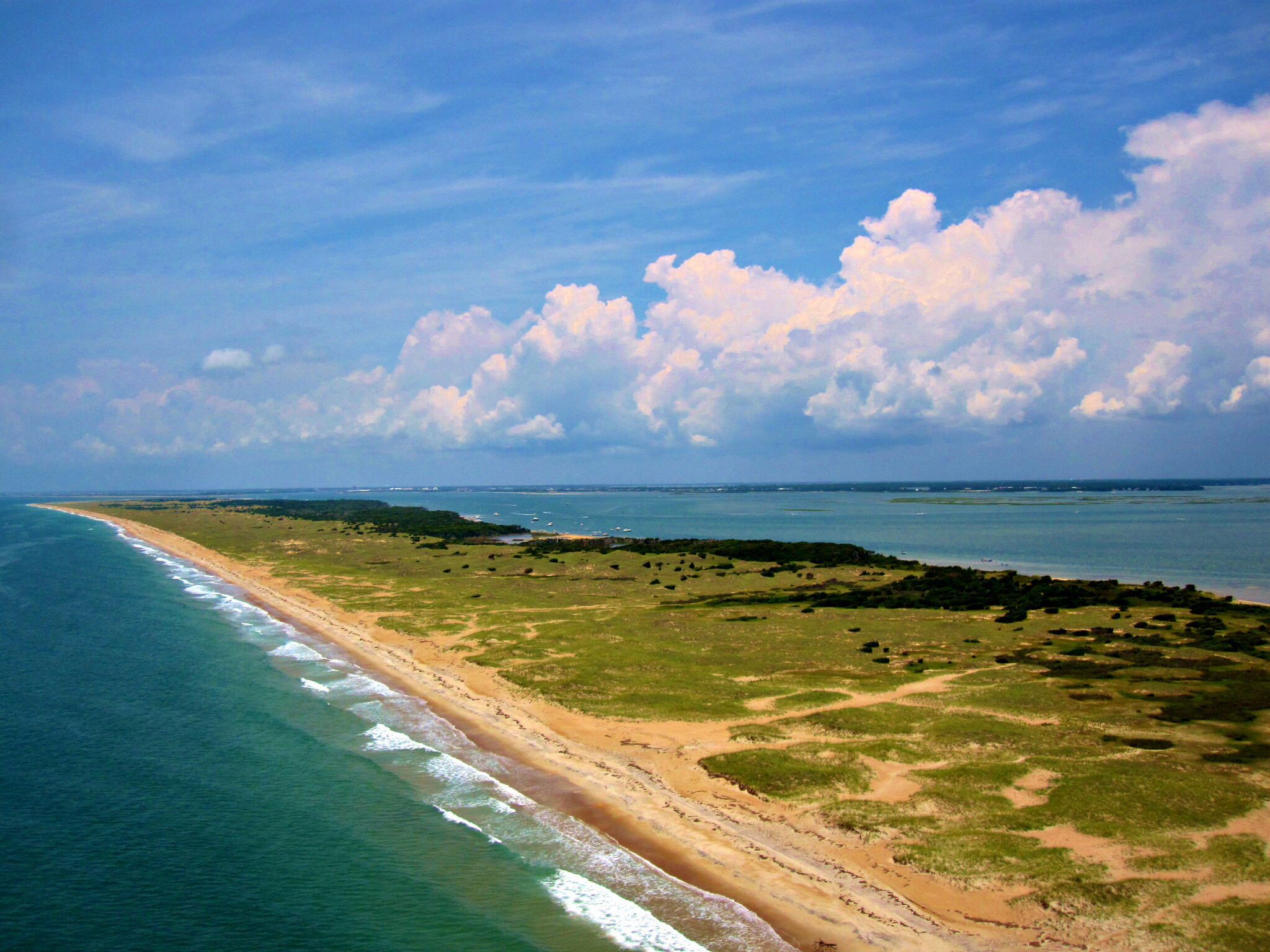
Southern Core Banks–Cape Lookout–Cape Village
Story


do you know more? contact me.
The 1917 Coast Guard Station
The station holds historical and, for locals, personal significance. After retirement of use as a lifesaving resource, it became the site of a Marine Science School and is now being refurbished (and leased) to become an education center under a non-profit organization.
Those who lived or spent time at the Cape repeatedly share their childhood memories of Guardsmen saving for them leftovers from the galley, treating them to ice cream and playing pool on the table upstairs in the equipment building. Whatever the problem that arose, the crews pitched in to help locals.

Dec. 29, 1988—Nomination for National Register of Historic Places—- excerpted–
Natioanl Park Service, Southeast Regional Office
Construction began 09/09/1916 with modifications through 1945 (end of WWII)
Initial Contractor: Schull, of Newport, N.C.
The nominated district consists of several buildings/structures on a deactivated U. S. Coast Guard (USCG) station on Core Banks, one of the barrier islands comprising the Outer Banks of North Carolina. The station site lies almost one mile north of Cape Lookout Point and 1 1/4 miles south/southeast of Cape Lookout Light Station. The basically rectangular 5.39-acre district encompasses coastal dune and shrub environments. The most important contributing elements in the district are the Main Station, the Galley, and the Equipment Building. Four additional contributing elements and ten noncontributing elements also lie within the district.

The thinly vegetated dunes, expansive lawn, and paved parking area provide a spacious setting for the few large buildings remaining on the station. Contributing to this sense of spaciousness, the Main Station and Equipment Building are more than 150 feet apart. The Main Station and Galley lie within just a few paces from each other in the dune environment and are on the highest site in the district. The Equipment Building is situated at a lower elevation, in a maintained grassland, probably carved from the nearby shrub thickets. Foundations of a generator room and a storage shed lie northeast and south, respectively, of the Equipment Building. Photograph below shows the district as it appeared in the 1920s.


This type of station is traditionally referred to as a “lifeboat station” by the USCG. The main purpose of such stations is to warn mariners away from danger and provide search and rescue for ships in distress. The use of this location for a lifeboat station predates establishment of the USCG in 1915, as the present station replaced a similar but more compact complex built in 1888 by the U. S. Life Saving Service (USLSS).

ITEM 8 – – SIGNIFICANCE
GENERAL STATEMENT OF SIGNIFICANCE OF CAPE LOOKOUT COAST GUARD STATION
Cape Lookout Coast Guard Station is significant because of its prominent role in the maritime heritage of North Carolina. It was one of twenty-nine “lifeboat” or rescue stations operating in North Carolina when it was completed in 1917. Although only one of several rescue stations that guarded the often perilous coastline of North Carolina, special status is conferred on this station because of its location near Cape Lookout Shoals, one of the three most feared shoals in the coastal region known as the “Graveyard of the Atlantic.”

The sea lane paralleling this dangerous coast was a vital link in a busy maritime transportation industry carrying countless passengers and vast quantities of commercial products to major maritime ports along the coast. A combination of factors including primitive vessels, violent storms, and the extensive nature of nearby Cape Lookout Shoals made this locality a deadly net for ships engaged in both coastal and transoceanic trade.
DETAILED STATEMENT OF SIGNIFICANCE OF CAPE LOOKOUT COAST GUARD STATION
“One of the world’s major shipping lanes passes just off the east coast of the United States. . .,” including the North Carolina coast. This lane has been a busy transportation route between New England and the Caribbean for commerce since colonial times. Cape Lookout Coast Guard Station is significant because it was an important link in the somewhat tenuous chain of U. S. Coast Guard Stations protecting ships and sailors plying this important maritime commerce and transportation route. More significance is conferred on this station for its location in a particularly dangerous area, important role in the maritime heritage of North Carolina, association with early USCG history, the relatively unaltered condition of the nominated buildings, and its relation to other North Carolina USCG stations. The “period of significance” extended well into modern times.
Nearby Cape Lookout Shoals provided the major impetus for establishing a lifeboat station here. The shoals extend approximately ten miles into the Atlantic. The length of these shoals, and still primitive nature of both sailing and motor vessels at the time the present station was constructed, made this an extremely hazardous area for ships. The position of the shoals directly in the course of coastwise traffic increased the risk of a ship becoming caught in this deadly snare. State significance is conferred on this station because of its role in protecting a shipping route and maritime industry carrying passengers and cargoes to ports in North Carolina, all along the eastern seaboard, and to international destinations. For hundreds of years nearby Cape Lookout Bight was a “haven” for ships threatened by storms and it served as an important rendezvous. British warships anchored there during the Revolution; and Europe-bound convoys gathered there in both World Wars. The station provided protection for vessels seeking this sheltered anchorage. Because of Cape Lookout Shoals, crews of this station had the most hazardous duty of the three stations on Core Banks.
Most, if not all, of the early crew men of the USCG station were from the local communities of Harkers Island, Marshallburg, Gloucester, Beaufort, etc. Almost every “old” family has relatives who served at this station and called it “home.” The crews of this station were noted for making “daring rescues.” Local people are very aware of their Life-saving legacy. They are extremely proud of the history of heroism and the hardships associated with the service of their family members. This station remains an important physical link to their past and the maritime heritage of all North Carolinians.

The Main Station building was one of three stations of the same design built along the North Carolina coast. The two sister stations, Cape Fear and Hatteras Inlet, have not survived. The design of this station transcends the evolution of the U. S. Life-Saving Service (USLSS) and U. S. Revenue Cutter Service into the USCG.
The Cape Lookout Coast Guard Station retains the character of its early years. The austere design of the buildings illustrates that function was more important than fashion. The dominance of the Main Station, with its watchtower providing a high vantage of the ocean and sound, immediately establishes that this was an important place to observe the passage of ships. A 24-hour watch was maintained from this watchtower until search and rescue operations ceased in 1982. Coast Guard plans to discontinue the 24-hour watch in 1976 were strongly opposed by local people and related political lobbying convinced the Coast Guard to continue the watches.


The proximity of the Galley to the Main Station accents its value in supporting the station operations. The historical function of the Equipment Building in storing vehicles, Life- saving apparatus, etc., is readily interpreted through the four large overhead doors. Although the Equipment Building was built much later than the other two buildings and is slightly less than fifty years old (in 1986), its importance in supporting station activities during the period of significance and its visual contribution to the historic scene is evident. Each building is on its original location.
There were three stations on Core Banks: Cape Lookout Coast Guard Station, Core Banks Coast Guard Station (#189–“Atlantic”) and Portsmouth Island Coast Guard Station. Core Banks Coast Guard Station, approximately twenty miles north, was the station closest to Cape Lookout Station on the Core Banks. This station, built by the USLSS in 1897, was lost to fire and erosion of the site. The Portsmouth Island station, built by the USLSS in 1895, also predates the existing Cape Lookout Coast Guard Station complex but not the original 1888 station at this site. The Core Banks and Portsmouth stations were both closed by 194O. The Portsmouth Island Station is now owned and maintained in good condition by Cape Lookout National Seashore.
The architecture of the Main Station at Cape Lookout Coast Guard Station occupies one of several niches in the evolution of USLSS/USCG search and rescue stations along the North Carolina OuterBanks. Much of the evolutionary process was related to changing personnel complements, rescue functions and the assignment of station equipment which resulted in the need for different architectural style buildings. Every major change in architectural style in USLSS/USCG stations along the South Atlantic Coast is found in the National Park System. A chronological list of these stations is:
1874 Little Kinnakeet LSS
1878 Bodie Island LSS and Chicamacomico LSS
1888 Cape Lookout LSS
1895 Portsmouth Island LSS
1904 Little Kinnakeet LSS
1916 Cape Lookout CGS
1925 Bodie Island CGS
1939 Cape Hatteras CGS (presently leased to Service by the U. S. the National Park Coast Guard)


The “period of significance” of this district extends from 1916 through the end of World War II, although the USLSS had established a station here for similar purposes in 1888. An earlier initial date for the significant period is precluded by the absence of any important element(s), except possibly a cistern, surviving from a period before 1916, the year the USCG started construction of the Main Station and Galley. Conditions during the 1916 to 1945 period made this station an indispensable link in the North Carolina search and rescue station system. The process of converting from sailing vessels to motor vessels was not completed by 1916; “more sailing vessels than ever were plying the coastal routes” during the years immediately prior to World War I. The greater number of sailing ships, more at the mercy of storms than motor vessels, provided abundant prey for shoals along the North Carolina coast. Relatively primitive navigation and weather forecasting technology increased the risks of encountering shoals and exposure to storms, respectively, throughout most of the pre-World War II period. The advent of World War II increased the significance of many stations. The importance of USCG stations in assisting with monitoring our coast to protect against enemy activities, such as submarine attacks on coastal shipping and infiltration by saboteurs, and to provide rescue is widely recognized. Nearby Cape Lookout Bight, protected from enemy submarines, became an important daylight anchorage for ships operating between Hampton Roads, Virginia and Charleston, South Carolina. Of eighty-seven vessels lost off the North Carolina coast from various causes during the war years, eighteen were lost near Cape Lookout. Three ships were torpedoed off Cape Lookout on one night alone in March 1942.
Search and rescue operations were conducted from the station many years after the war, in fact until 15 May 1982, well beyond the end of the “period of significance”—evidence of a long continuous desire for maritime rescue services in the locality. The significance of this station waned with the end of World War II. As related in the last chapter of Graveyard of the Atlantic – Shipwrecks of the North Carolina Coast, the frequency of shipwrecks/sinkings occurring since World War II has greatly diminished. Appropriately titled, “The Romance is Gone”, this chapter explains that improvements in shipbuilding, navigation, weather forecasting, communications, etc., have greatly reduced the risk to seafarers. These same technological advances also reduced the need for stations to be as close together as they were in the early years; each station could serve a greater area than possible before such innovations. With these improvements, Cape Lookout Coast Guard Station became less important for providing rescue services and eventually came under the administration of Fort Macon Coast Guard Station. Fort Macon Station became the primary responder to major disasters. Cape Lookout Station remained operational to provide rescue services for small commercial fishing boats and private pleasure boats in the nearby shoals, bight and sound. Although the station was relegated to minor rescue functions, a variety of new assignments postponed closure. Cape Lookout Lighthouse was converted to an unmanned, automatic light in 1950. Responsibility for maintaining and monitoring the lighthouse was subsequently transferred to the Cape Lookout Station. Other functions in later years included operating a radio navigation station (previously a duty of the lighthouse crew) and enforcing marine safety regulations. The cost of maintaining this station as an outpost on an isolated barrier island, with no bridge or other physical link to the mainland, was relatively high. A major budget reduction convinced the USCG that nearby Fort Macon Station must completely replace Cape Lookout Station. Cape Lookout Coast Guard Station was officially decommissioned on 10 June 1982.
(David Stick, The Outer Banks of North Carolina (Chapel Hill, North Carolina: The University of North Carolina Press–frequently referenced in the application)

DESCRIPTION OF CONTRIBUTING ELEMENTS DURING THE PERIOD OF SIGNIFICANCE
The entire complex is a business-like collection of buildings and structures supporting marine search and rescue operations. The buildings are sturdy but unadorned. Function, not architectural beauty, was the principle objective in construction. Descriptions of the Main Station and Galley are based on existing historic fabric and the original specifications and drawings that the contractor followed in constructing these buildings.
Element Number 1; Main Station
The Main Station, being the tallest structure and situated on high ground, dominates the district. Construction of this essentially rectangular 44’5″ by 24’9″ two story building began on 9 September 1916 and was completed on 1 June 1917.
The Main Station provided both office space and living/sleeping quarters for the station crews. This building was originally designed to accommodate a crew of nine.
The building appears to be an austere interpretation of the Neo-Colonial mode of Georgian Revival architectural style. This style is described as “. . .strictly rectangular in plan, with a minimum of minor projections, and . . . strictly symmetrical facades. Roofs are hipped . . .; [with] a central cupola. Chimneys are placed so as to contribute to the over-all symmetry.”
A watchtower, or cupola, two chimneys, and “gable on hip” roof crowned the Main Station. The watchtower is centered squarely upon the roof. In terms of form and historic use of the building, this watchtower, with its eight windows, is the most important architectural feature. It is from here that watches were maintained to scan surrounding waters for ships in distress. The chimneys flanked the watchtower, one each at its east and west sides. The roof was originally sheathed with asbestos shingles and their fragments may still be found on the grounds immediately around the structure.
The attic space is divided into two small rooms. Their use has not been firmly established, but most probably were storage. A small window in each gable provide dim natural lighting for the space.
The layout of the two main floors was uncomplicated. The second floor layout remains, as constructed, divided into four bedrooms. The first floor was originally divided into a “spare room,” storm clothes room, crew’s room, crew’s bathroom (no toilet), keeper’s room, and an office. Original wall finishes in the rooms were lathe and plaster; the storm clothes room and stairway were “wainscoted or ceiled”. Twelve large windows on the second floor and ten more on the first admit abundant natural lighting.


Photographs, interviews with retired Coast Guard staff, a copy of original specifications, and on-site inspection of historic fabric indicate that the original exterior finish was 5 1/2″ wide beveled clapboards, painted white. A large (28* X 8′) porch with roof and concrete floor projects from the center of the south, or “front,” elevation of the first floor. These doors are arranged symmetrically under the roof of the porch. Three doors may be originals because they are fitted with windows in their top halves as shown in plans and early photographs. Another door, just east of center, provided access to the north, or “back,” side of the house, into the storm clothes room.
The building rests on a concrete foundation and a half basement. Four rooms comprise the basement. Two of these are a coal storage room and a boiler room.
The existence of a coal storage room indicates that the original boiler was coal-fired. The boiler supplied hot water circulated through cast iron radiators heating most rooms on the first and second floors; these radiators are still present. Another room was used as a storm clothes room.
Element Number 2; Galley

The original layout of this one story building was rectangular, 19’8″ by 15’8″. Construction of the Galley probably started shortly after the Main Station was completed in 1917. It served as both kitchen and mess hall. This clapboarded, wood frame building was extremely basic and did not have distinctive architectural qualities that suggested any certain style and is best described as vernacular.
The building was topped with a simple gabled roof, covered with asbestos shingles. An exterior chimney protruded above the roof from the center of the north wall. This single room building had two windows each in the north and south walls and one each on the east and west walls.
Siding material was the same as that used in the Main Station. There was one door on the east wall and another on the west. Simple wood steps, three risers each, were provided for each door. The Galley rested on concrete piers.

Element Number 3; Equipment Building

The plans that the Equipment Building were built from provide information on its original design. This rectangular, 50’6″ by 32’5″, building was constructed in 1940. It was used to house rescue equipment and vehicles used in general station operations. This one and one half story wood frame building possesses characteristics of the “Southern type” of Colonial Architecture. Whiffen describes this architectural style as, “. . .one story or a story and a half [that is, with dormer windows lighting rooms in the roof], . .”.
The building is topped with a simple gabled roof and eight dormers ,with four dormers on the east and west sides. The roof was covered with wood shingles, according to original generic plans.
The exterior of this building was sheathed with wood shingles, according to original generic plans. Four large, garage-style, overhead doors provide access for vehicles and large equipment. A fifth standard size of swinging door provides access for personnel.
The upper half story is divided into three rooms. The first floor was undivided, except for a small (81 X 81) “shop” in the southwest corner and an adjoining smaller furnace room. The interiorisplywood. The building rests on a concrete foundation slab.


Element Number 4: Cistern

The cistern, lying between the Main Station and Galley, was built under the same contract as those two buildings. This concrete/masonry structure, almost entirely below grade, is 32′ long X 7’wide X 6’deep. The cistern supplied water for the station. Water was collected from the Main Station roof through a series of gutters, downspouts, and transfer pipes.
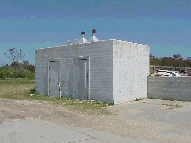
Element Number 5; Generator and Radio Beacon House

A concrete foundation slab is all that remains to mark the location of the Generator and Radio Beacon House that laid approximately 50′ north of the Equipment Building, This 25′ X 14′ wood frame structure sheltered the station generator and radio navigation equipment. Documentation for the construction date of this building has not been found. The house was identified by a retired Coast Guard crew member in a 1941 photograph of the station.10 Existing photographs and plot plans suggest that this simple building never possessed any particular architectural style.
Element Number7: Cistern
This above-ground cistern lies within a few paces west of the Galley. The concrete masonry cistern is 21’ long X II1sid X 10’ high. Its construction date is not documented but probably dates to the period of the USLSS and shows in a 1920’s period photograph of the station, abutting the relocated USLSS Station.
DESCRIPTION OF CHANGES IN THE DISTRICT, INCLUDING NONCONTRIBUTING ELEMENTS, THROUGHOUT THE YEARS
Numerous changes occurred in the composition of district elements since the USCG was established in January 1915. An undetermined number of buildings built by the USLSS remained on the station well past establishment of the USCG, and when construction of the present Main Station began on 9 June 1916. The number of buildings in the district, however, has greatly diminished throughout the years. The USLSS Main Station remained in the district until it was sold to a private individual and moved approximately 1/4 mile north in I960.11
The USLSS Main Station served as a U. S. Navy radio station for an undetermined period between its replacement by the USCG Main Station and later removal.12 The only remains of the USLSS station is a cistern, Element Number 7.
Although elements 1 through 7 were altered or modified to varying degrees during USCG occupation of the complex, the importance of these elements remains undiminished. In many ways these changes contributed to understanding the evolutions of functions and technology of USCG stations. Elements 8 through 17 are classified as “noncontributing” because they are less than fifty years old and were not essential to station operations.
Element Number 1; Main Station

Although the Main Station originally accommodated only nine men, it housed 21 or 22 men in later years as the station complement increased.
The short spire on the watchtower is now gone; the date it was removed is not known. The east chimney was truncated just below the roof, evidently prior to 8 November 1972 because plans of that date do not show it. The original red asbestos shingles were replaced by wood shingles in 1945 because they discolored the cistern water. The building was again “reroofed” in 1972 or 1973, with asphalt shingles. Asphalt shingles cover the roof presently. (1986)

Minor changes occurred to the floor plan by 1958, except for the second floor which essentially is unchanged. The first floor layout, however, was slightly altered when the “spare room” was converted into a bedroom, without changing its original dimensions. The storm clothes room became a complete bathroom for lower ranking crew. The “officer in charge” took exclusive use of the original crew’s bathroom. Present bathroom finishes and fixtures are modern; fixtures in the crews bathroom were replaced in 1972. The crew’s room remains unchanged. It appears that the interior finishes of these rooms were modernized several times. Gypsum wallboard and a lowered suspended acoustical tile ceiling were installed in 1976. Masonite wood grain panelling presently covers most interior walls.
Another inconspicuous modification includes installation of new wiring in 1958. Air conditioning was installed in either 1975 or 1976.
The exterior has also been altered in several minor ways. White- colored aluminum “clapboard” siding was installed over the original siding either in late 1972 or 1973.21 Recent inspection reveals that the original siding remains beneath it. All original wood-framed windows were replaced by aluminum-framed windows when the aluminum siding was installed. Except for the addition of screening and related framing, the porch is essentially unchanged; the date of this change is not known. An original doorway on the north wall was boarded over when the storm clothes room was transformed into the crew’s bathroom.
The use of the basement changed somewhat over the years. The coal storage room became a general storage room when an oil-fired boiler, perhaps the present one, replaced the original boiler. Modern laundry equipment is also located in the basement now.
The original character of this building is intact because such alterations/additions did not involve major replacement of structural elements or greatly affect overall appearance.
Element Number 2: Galley

Architectural evidence gathered by studying differences in flooring materials, ceiling, and siding materials indicates that two additions to the Galley were made. The building was extended approximately 15’ southward at an unknown date. This addition did not occur prior to 1941 because it does not appear in a photograph of that date. A screened porch was added to the east side in 1982. These additions are supported by concrete piers. Approximate dimensions of the porch are 32′ (north to south) X 14′. The present architectural quality of this building is best described as “vernacular.” Aluminum “clapboard” siding probably was installed when the porch was added. Although more extensive inspection would be needed to determine the exact structural impact of these alternations, the following is noted:
The two windows on the north wall have been closed over. – The south wall has been replaced once. The door on the west wall has been closed over. The chimney was removed in 1975. Both existing exterior doors open out onto the porch. The interior has been extensively modernized throughout the years.
New lighting fixtures, appliances, (patterned) vinyl wall covering, and new linoleum etc. were installed between 1979 and 1982.
A comparison of the original plans with the present layout of the building shows that a number of original features are preserved. The east door and windows on the east and west sides remain. Although the south wall was replaced, it is fitted with two windows in the same relative locations as were in the original wall.
Although this building was extensively altered and added to over the years, the basic architectural simplicity and original use of the building remained intact. Except for the south wall, most of the original structural components were retained. The additions to the Galley reflect the evolution of the station into an increase in crew size and more comfortable living conditions in later years.
Element Number 3: Equipment Building


Aluminum siding presently covers what may be original shingle siding. Documentation of the date of this relatively modern alteration has not been found.
The interior was altered by the installation of two large electrical generators on the first floor at the north end of the building in 1963 or 1964. Radio beacon equipment was also installed at that time in the north end of the upper half story. The radio beacon equipment was removed in 1979. The wall dividing the generators from the remainder of the first floor was built when the generators were installed. The few modifications described above neither significantly changed the general appearance of the building nor abolished its function as storage for vehicles and rescue equipment.
Element Number 4; Cistern

This element is apparently unchanged from its original specifications. It apparently served as a primary water supply for the Main Station and Galley in early years.
Element Number 5; Generator and Radio Beacon House
This building was probably razed in 1963 or 1964, after generators and the radio beacon were installed in the Equipment Building. Only the foundation remains. An incinerator was installed on the foundation by the National Park Service and USCG in 1977. The foundation is in good condition and clearly identifies the location of the original structure. The foundation contributes to understanding the character of the station complex.
Element Number 6; Storage Building

The date that this building was razed is unknown. The foundation and ramp are in good condition and clearly mark the location of the building. The foundation continues to contribute to understanding the evolutional process of the district.
Element Number 7; Cistern
This may be the oldest extant structure in the district. It is probably a physical link between the USLSS station and the USCG station.
This structure was modified into a (flammable) liquids storage shed (date unknown). Modifications include installation of two doors and two turbine style ventilators on the roof. The basic shape is unchanged. For this reason and the relatively intact quality of the cistern, this is a contributing element.
Element Number 8; Picket Fence

Photographs of the Main Station and Galley show the picket fence surrounding those buildings. Comparison of these photographs with earlier photos indicates that the picket fence replaced an earlier post and board fence. The construction date of the picket fence is c.1950. The fence is approximately 300 ’long and 4′ high. It was extensively repaired in August of 1987 in accordance with an approved “Assessment of Actions Having an Affect on Cultural Resources.”
Element Number 9: Concrete Walk
A concrete walk connects the Main Station to the Galley and paved parking area adjacent to the Equipment Building. Initial construction began in 1926, but numerous repairs and additions have been made since that date.31 Total length of the concrete walk system today is approximately 220′. Written documentation of repairs/additions is unavailable. However, “Crew of 1975” is inscribed on a section of the walk near the front porch of the Main Station. The walk was rerouted to accommodate the southward expansion of the Galley porch addition in 1982. The extent of any remains of the walk from the period of significance is not known at this time.
Element Number 10: Flagstaff

The flagstaff is a simple element. Severely bent now, it was approximately 35′ tall. There is no documentation of its original construction date, but it does not appear in any pre- 1946 photographs on file. The flagstaff is made of metal pipes secured at the base of two vertical 4′ tall 6″ wide U-beams.
Element Number 11; Pyrotechnics Storage Box

An aluminum box labelled “pyrotechnics” lies a few feet south of the flagstaff. The 2’11” X 1’8″ X 3’2″ (tall) box is anchored to a concrete base. The installation of this box is obviously recent.
Element Number 12; Fire Pump Shed
This plywood shed, sheathed with fiberglass, is immediately north of the Main Station. A stationary fire pump is still inside. The shed is 8′ X 4′ X 4′ 6″ (high) and rests on a concrete slab. It was constructed in 1972.
Element Number 13; Retaining Wall
A concrete retaining wall facilitated levelling/stabilizing the southwestern section of the Main Station/Galley yard. The wall is approximately 90′ long and 5′ high. This wall does not appear in a 1941 photograph and seems to be of recent construction.
Element Number 14; Concrete Parking Area and Road
A concrete parking area lies between the Galley and Equipment Building. This irregularly shaped pad is approximately 100’X 140′.12
A linear extension of the concrete parking area connects the station with the USCG dock that is approximately 3/4 mile outside the district. This concrete road is 8′ 10″ wide. Both the parking area and road were constructed in 1962 or 1963.33
Element Number 15: Fuel Storage Complex
A fuel storage complex adjoins the Equipment Building. The complex consists of seven metal fuel tanks, a concrete containment wall and pad, and an elevated wooden walk over the tanks. Four of the tanks are each approximately 5’ in diameter X 12’long. Two other tanks are approximately 35” in diameter X 12′ long. A remaining tank is oval; it is approximately 27″ wide X 45″high. The concrete containment wall is approximately 41’X 19*X 2′(high). This complex probably was constructed when the generators were installed in the Equipment Building in the early 1960s.
Element Number16; Fire Equipment Shed

A fire equipment shed is situated on the lawn near the southeastern corner of the paved parking area between the Equipment Building and Galley. The chipboard structure is approximately7’X7’X 9′(high). This shed is painted white and showing signs of minor decay. A wheeled fire hose rack is contained in this shed. The construction date is not known. The shed does not appear in photographs of the station dated 1979.
Element Number 17; Fire Equipment Shed

Another fire equipment shed is located next to Element Number 21. This board and batten structure is 7′ X 6′ X 9′ (high) . The exterior of this empty shed is painted red. It was built in 1976.
Gallery
Coast Guard Station–Cape Lookout–1916 till current day
(click photos to enlarge)


Credits
- NPS files and archives
- Historic Structure Report and Nomination for the Historic Registry documents
- Other references within text